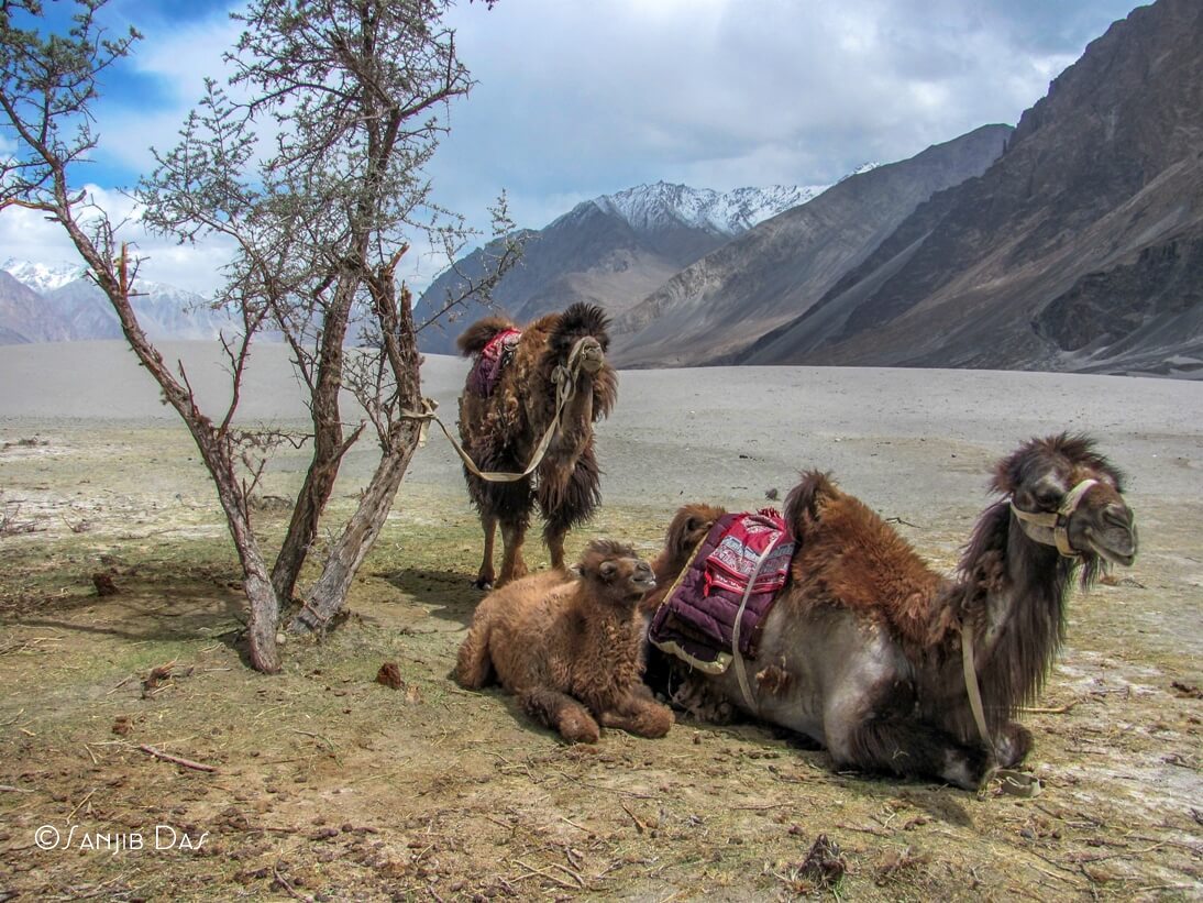
Khardungala top 50 km away from Leh. The bone-biting cold of the world, which is known to be the world’s tallest road, also remembers for a long time for its chill cold wind. After crossing Khardungla you will reach Khalasar, Hundar then Panamik, one after Khardungla. Near the Khalasar, the Nubra river mixed with the Shiak River. Cold desert to the Shyok river. There are Two humpbacked camels, green ointments, warm-blooded sweets – all of which are the journeys of an unmarked country.
The third week of May, we, five friends are on the way to Ladakh. From November to May, all roads in Ladakh remain closed. Eventually, we reached Delhi from Howrah and then on the air, after having one and half hour journey our airplane landed on the Indus riverbed, Leh airport.
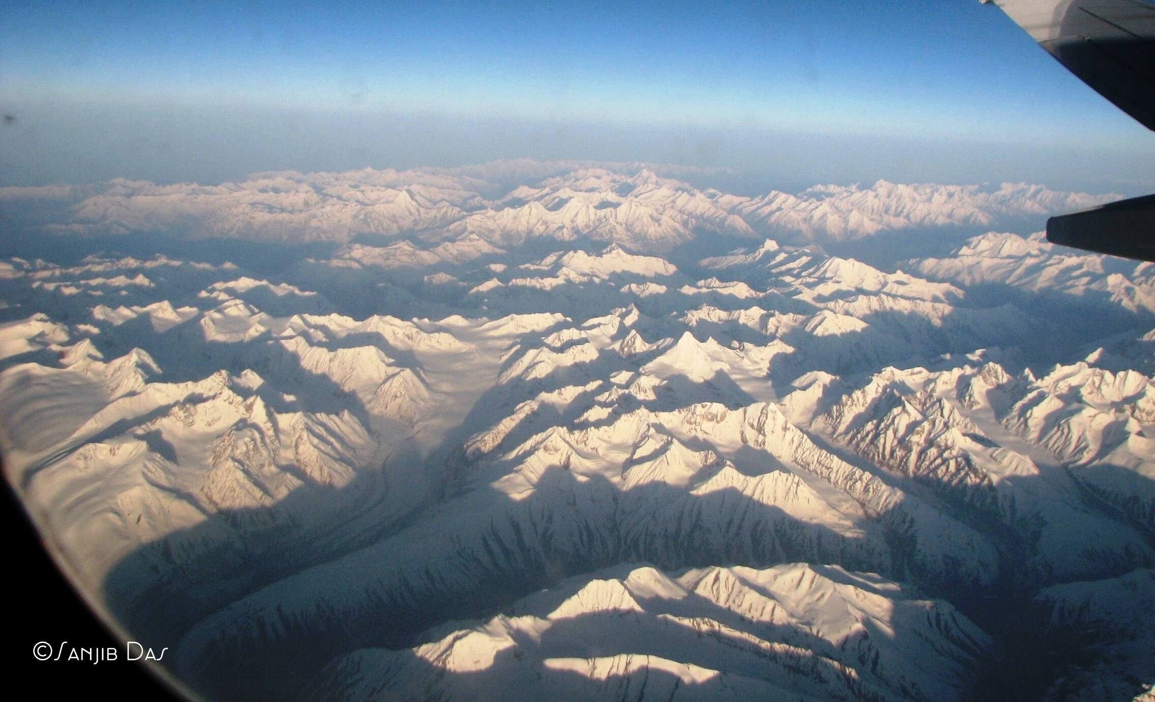
The airport is surrounded by the hills. Around 9 km north-east of the airport, the number 1 national highway traverses the heart of the city- Leh. A different class of hotels is available here. We got a budget hotel next to the market. The height of the city is 11,483 feet. To avoid the high altitude sickness problems and as we all are tired of spending an awakening night at Delhi airport, the rest of the day we stayed at the hotel.
The next day, in the morning, listened wake up call of the unknown birds busy in a quarrel. After moving the window screen, we saw the white-capped gray Ladakh Mountains.
Inner Line Permit was done earlier. Taken two days of rest in the town so that our bodies can be adjusted to the height and went on a two-day tour to Khardungla and Nubra Valley. This road is quite uphill in the north. Iqbal, the driver-cum-guide companion of this itinerary with five friends. His experience in this route is 10 years long.
Over time, the gray hills disappeared and the snow-clad hills took its place. Our car progressed slowly, on a dry scale like a snake made on snow-covered in ice. On this street, the directional panels of the road, like the cotton ice, are creating the water stream along with sunlight. On the mountainous side of the road, the water flowing on the hill has been frozen and taken shape in various forms of a crystal, and the morning sunlight radiates the rainbow color after falling on it. On the other side of the street, nature has created the architectural style of ice in the area.
After 30 kilometers of car drive, we reached Khardungla-height 14,730 feet. Due to the high elevation, almost all travelers are facing breathing trouble. After resting for a while, the car continued to rise further. In different places, the frozen showers asking us to go back. Suddenly, on one side of the road, while crossing a hard fountain we fall in deep danger. Iqbal was trying the steering turned right on the right side of the thick ice rug, and the wheel behind the car slipped towards the ditch. The heart rate of all people was stuck for some time. One of my co-traveler shouted, “ Iqbal, chess the brake”. Iqbal gave a counter-rebuke! Then he pressed the accelerator and pushed it across the road to the edge of the road by crossing the snow-shade.
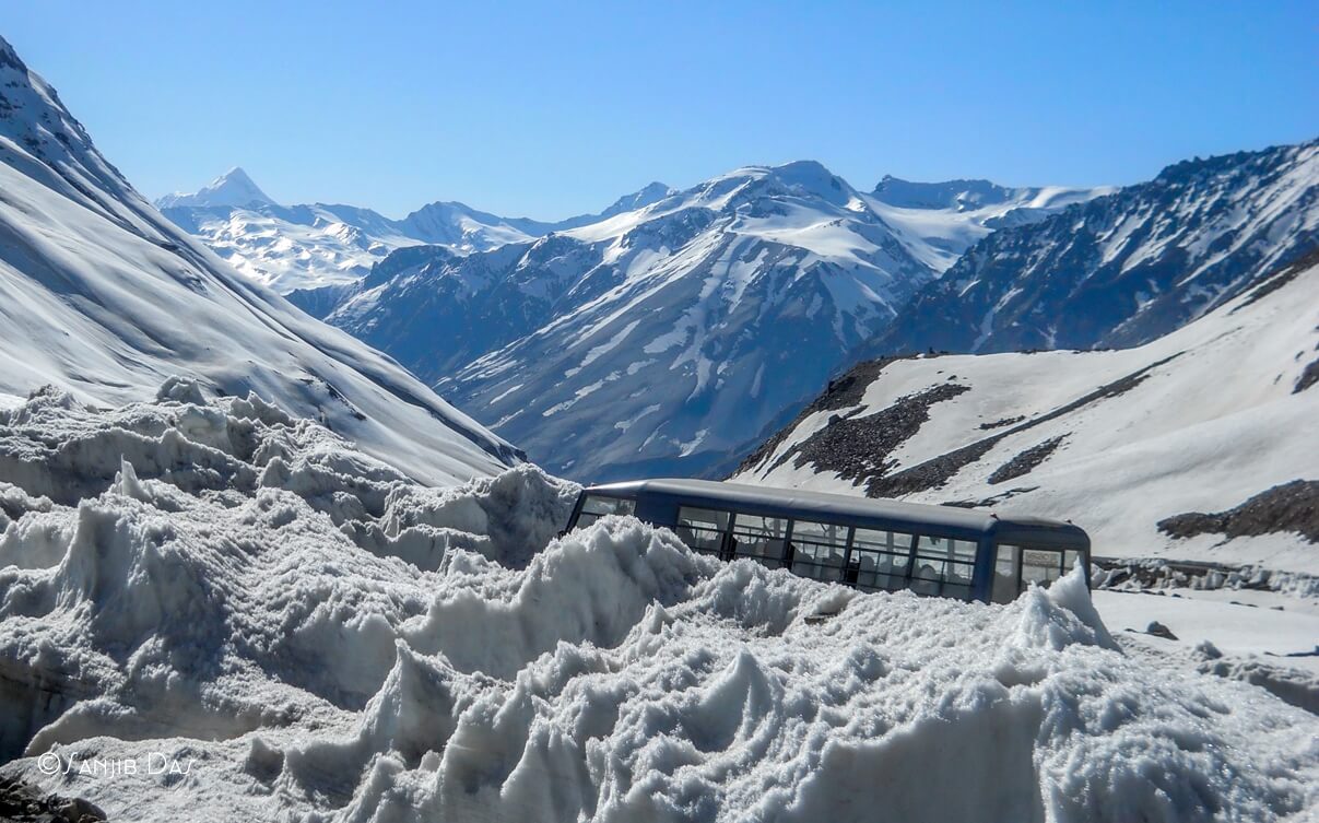
Iqbal came down from the car and stood in the street. Sitting inside the closed car we did not realize that the external temperature has dropped below the zero. The intense chill wind blew up the face. On the left side of the road, I noticed the wheels of the car, that the distance between the left corners of the road and the wheel along was just 1 or 2 inches. The depth of the ice-pit maybe 300 feet. The bottom part is dark, the light of the sun could not reach. Iqbal said, last year such a snow-trapped road driving a car broke into a car accident – four tourists were killed. There is a terrible silence all around. Everyone looked at each other and wordlessly. With the spine, the snowflakes flowed.
|| 2 ||
We reached Ladakh’s girishira by crossing the route of Ladakh Glacier, about 50 kilometers from the city on the escalation Kharadungala. After reaching the top saw the notice board “ it is the world’s highest motorway, height 18,380 feet. “ Although the information has been rejected in modern search. According to the GPS system, its height is around 17,582 feet.
The Karakoram to the north and the white mountains of the mangroves on the south. The white cloud floating in a clear blue sky is blowing like white cotton, and the sun-rays on the snow-covered mountain are just as beautiful as a picture on the white canvas. To cameras this amazing scene of nature, opening the glove, I was pressing the camera shutter, after a while I noticed that the fingers of fingers were numb. The temperature has dropped below the humankind (minus 12 degrees Celsius).In this region, movement without sunglasses during the day is dangerous, because the strong reflection of sunlight on ice is extremely harmful to the eyes. Siachen beside the side – the silence of the Indian army’s tents and soldiers.
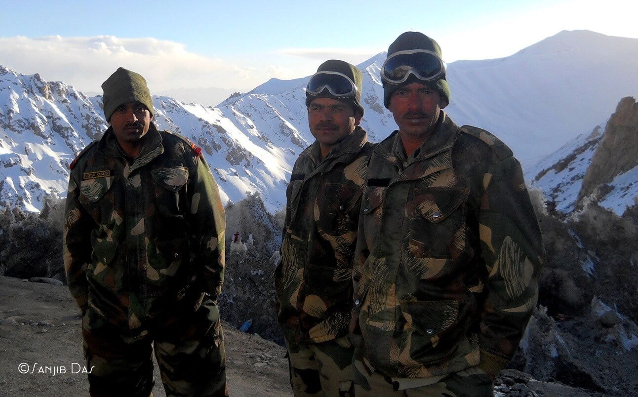
North Pullu, 15 kilometers north of Khardungla, and South Pullu, 15 kilometers south.Both the army camp. We got topped by South Pullu.On the way down the road to North Pulu, Khardungla, our destination is Nubra Valley, about a 100 km route. The starting point is quite bad. The road collapsed where the road broke. The side hills have melted water flow and the water-filled highway is very difficult to move on the road to the wheel. Come to North Pullu, the military armored vehicle on the white hills, weighing at a slow pace. Here the road is one-way. So Iqbal put our car near the army camp to give them a place to go.
Knowing the opportunity, my writer-friend gave the story to the jawans at the check post. We also joined the chat. Eventually, one of the jawans of the come from Bengal. Seeing the ethnicity in this unmatched deserted hill, the man naturally, became somewhat cheerful and emotional. In the context, I found some important information in 1973, some Indian soldiers who died while making this road on the pass. Siachen basecamp- the world’s highest battlefield when it goes on for more than 164 kilometers. And on the way, the Indian army goes to the base camp. So the importance of this road in the political context is undoubtedly unimaginable. In winter, the temperature here is minus 40 degrees Celsius. The road covered with 10 feet thick ice sheet. Then it became very hard for the army to keep continue the duty.
To go to the row of military cars, our car started moving again by greeting the real heroes. About 34 kilometers north of the pass found a few shops in Khardung village. A 12 pm got Breakfast. The next road is relatively good. On both sides of the road, the presence of greenery ice continued to grow. Yak, the sheep and the Kiang or wild asses saw on the way. Apart from this, there is a special reception in the tropical Himalayan Marmotte in the grassroots along the way.
|| 3 ||
After passing 58 kilometers from Khardungla we reached at Khalsar. The ice-cold water tilted the name of Nubra came from Siachen glacier joined here with the river Siyak. These two rivers created a green valley, which is known as Nubra Valley. ‘Nubra’ means ‘flower garden’, Valley of Flowers – Ladakh’s only oasis. Its average height is ten thousand feet. Externals are prohibited without permission from the permit here. So by submitting a copy of the permit made on the lease by depositing it on the check post, we entered the Nubra Valley, which separates the Ladakh and Karakoram mountains. In addition to wheat, barley and other rains, winter fruit, apricot and walnut are cultivated here. Local people speak the Ladakhi language. Even though most Buddhists, there are also some Shia and Sunni Muslims.

From Khalasar, two roads have passed on both sides of the valley. About 19 kilometers east on the left road, we reached Diskit, the largest village in the valley. There have been accessing the shops and markets in the bank services. The main point is the 600-year-old Diskit monastery. Rows of Buddhist colorful prayer flags flying over the head. Here’s an exciting feeling of seeing the world’s second-highest peak K-2. After walking seven kilometers, Iqbal stopped our car by a narrow river.
We got a surprise scene from the car. The gray haunts seen from long distances are now surrounded by our four sides. At the height of the high mountain, the shape of the crystal has been shaped by the light of the evening falling on the ice layer. Although the heat of the sun is quite high, the water of the Shyok, which is flowing in the word, is as transparent as the cold. We crossed a small bamboo crossing on the river. The sea of white sand dunes in front of the mountains. Hinges are spreading thorny bushes. This is the famous Hundar. India’s highest desert, at an altitude of 10,000 feet. Two humpbacked hairy camels are roaming in this cool dessert. They are the bacterial camel species of Taklamakan and Gobi Desert in Central Asia. Riding on the camel, one another sensual feeling on this trip to the Desert-Bihar. The cost of the camel is 150 rupees per 15 minutes. Tents can be rented out for a short distance. According to the standard rent is different. We chose two common tents. Ladakh has the light of day, till eight o’clock. During the night with dinner, I looked asleep in the dark light of the night and looked at the hills when I fell asleep.

The team manager Sujitda called on the next morning. Time was 8 am. Although the sun is in the mountains behind, all the valleys were filled with a dreamy soft light of the morning. Momo and Soup went to breakfast with Hundar after going out to leave for Panamik.
Khalsar to the north – it took more than a minute to reach Panamik by road from. Here, the warm-blooded chemical reaction that has developed in the non-stop areas of the underground blossom creates a variety of colors on the stone. I could not cope with the temptation of bathing in the geyser in winter. Panamik is the last village of Ladakh, as long as the tourists get permission to go. Then this road went straight to the Siachen base camp, distance 94 kilometers.
|| 4 ||
Now time to return to Leh, on the return road. All of the newly sighted eye-catching images are rotating on the head The rough oasis of greenery, the cool desert in the lap of the barren hills, the river flowing through it, the hot water source – simultaneously, this diverse form of nature is not only in India but it is rare in the world or rare in the world. The carriage started moving uphill. Late in the evening.
The tour is over, now it’s time to return home. It will take two days, 477 kilometers distance, to reach Manali via Le-Manali highway, opened in 1989, and the name of the 21st National Garment. But the diverse tour of these two days is the climax of Ladakh Tour. On the way back, a peculiar tropic of grounds at a height of 15000 feet – Mori plateau have been on the roads built by the Border Road Organization on the plateau and hills, I saw a lot of brown Tibetan donkeys. After the 167-kilometer road, lunch at the Pang-A (15,200 ft) hotel at the tent’s house. After this, more than 10 kilometers ahead of the road, naturally created stone archway ‘Gateway of Ladakh’ said our goodbyes. Lacungla (16,616 feet), if there are more than 14 kilometers of uphill. From here, on the downhill road, at a distance of 57 kilometers, the end of Jammu-Kashmir and the beginning of Himachal Pradesh. Calling the route from the square to the hour, I stayed here for a night. The next day, Manali (6, 726 feet), 188 kilometers away from Rohtang Pass (13,054 feet) – from there we reach Delhi on the way back to Howrah.
Though the tour ends, the colorful pictures of this journey will be filled with deep emotional life. Not just the natural beauty of Ladakh, the heartless sentimentality and environmental awareness of Ladakhi people, which were known throughout the journey in this remote hostile environment, touched the heart. Wonders of Awakening The simple life of the people. By embracing Iqbal, I felt a spiritual bond. Iqbal just said ‘Alvida buddy’ with a sigh of relief.
Necessary Information
When to go –
June to September in the spring and summer of LadakhThe ideal time to travel. This time the streets of Manali and Srinagar are also open.
Inner Line Permit
There is no official permission need to see places near Leh city. but the Inner Line permit is required to go to most places far away from the Indian suburbs. Permission will be available on the submission of credentials and photos at the DC office. Take 6-7 photocopies with them. These must be submitted to the Military Check Post at the time of the journey.
How to go
From Delhi, Srinagar and Chandigarh regular airports going to the airport. From there, the hillside Leh town is 9 kilometers away. Apart from this, the distance from Srinagar to Leh 434 kilometers. One-night stay in Kargil, From Manali to Kelang-Charchu, you can also go to Leh. distance 473 kilometers. That will take 2 days.
Car Rentals
Le taxis have set a fixed fare for Ladakh sites. Travelers can choose cars and places as needed.
One day, to take a look at the sightings near the city of Le, the car will cost around Rs.860. Nubra Valley costing 1 night 2-day trip will cost 8,369 rupees. Soon to spend 1 night 2 day trip to Moriri lake, cost 9,345 rupees. In Pangong lake, the cost of 1 night 2-day trip will cost Rs.8,159. On day-to-day Pangang lake costs Rs 6,854By going out in the morning, going back to the Aryagram, the cost of returning to the evening will be 6,151 rupees. If you want to go to Alchi Gompa and Lekhi’s Gompa, then you will need 600 extra.
To travel, Sumo, Kwality or Scorpio will have to take a national car. More than 6 passengers are not usually taken in a car. However, remember that with the decrease in oil prices, the cost of the carriage is rising. Contact for vehicle: Iqbal, Phone – 09469262312. Sonam Sherring, Phone- 094193-72817
Where to stay there
are several hotels to stay in Le Town:
Yak Tel (0192-2258), rent 1,800-2,000 rupees
Hotel Hilton, Le Palaces and Siachen rentals 2,200-2,700Booking: 98302-58828
Hotel Kangri (94320-13131), Rent 2,200-4,000 Taka
Dewan International, Thongle Guesthouse, Rent 1,500-2,500Booking 2417-4501
Hotel Dreamland (4060-5152), Rent 1,400-2,200
The Golauan Guesthouse (94326-4991), rent 1,000-1,500
Remember that
it takes 1 to 2 days to reach the city of Le, adjusting the body with height is very important. Keep up with homeopathy medicine Coca-6.Highly elevated problems (such as a headache, respiratory failure, vomiting, etc.) due to the low levels of oxygen. Here you have to take warm clothes with suncap, sun protection cream, sunglass and vaseline. For each member of the Inner line Permit, 6 copies of each member shall be accompanied by the identity card and voter card.For more information, see the official website of Ladakh leh.nic.in